Zoning
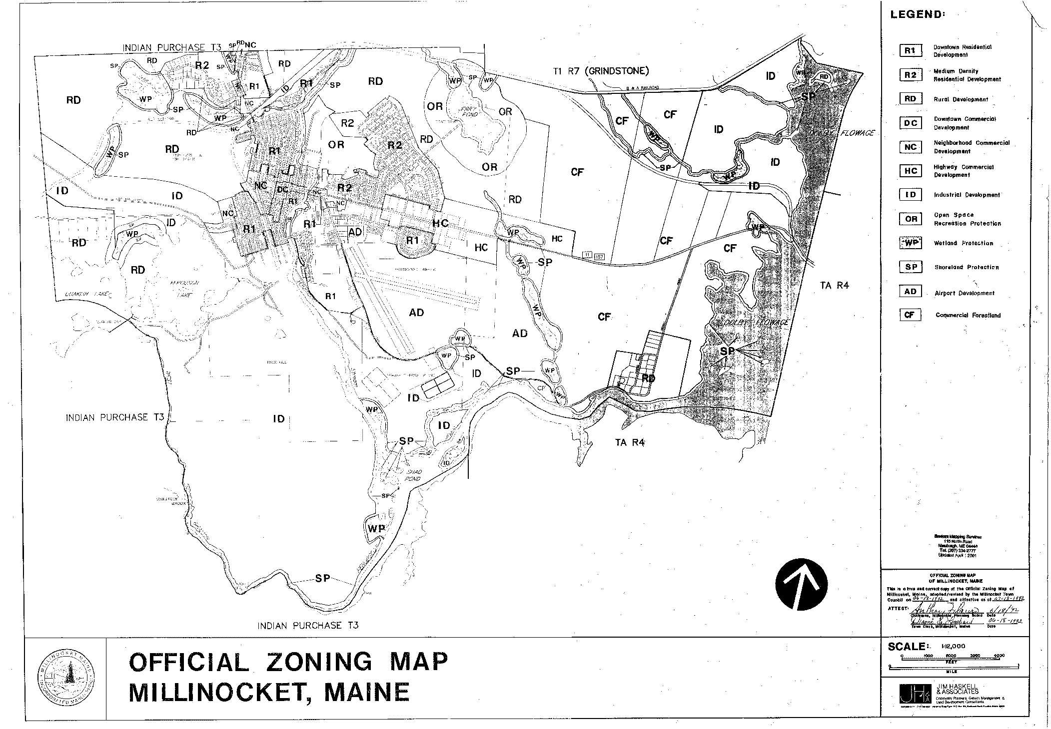
A. Downtown Residential Zone (R1).
B. Medium Density Residential Zone (R2).
C. Rural Development Zone (RD).
D. Downtown Commercial Development Zone (DC).
E. Neighborhood Commercial Development Zone (NC).
F. Highway Commercial Development Zone (HC).
G. Industrial Development Zone (ID).
H. Airport Development Zone (AD).
I. Open Space/Recreation Zone (OR). j. Wetland Protection Zone (WP).
K. Shoreland Protection Zone (SP).
L. Habitat Protection Overlay Zone (HP).
M. Commercial Forestland Zone (CF).
§ 125-33. Standards for establishing zones.
A. Downtown Residential Zone (R1).
(1) The purpose of the Downtown Residential Zone (R1) is to preserve the character of existing downtown residential neighborhoods and to provide high-density residential opportunities and neighborhood characteristics within the service area of existing public sewer and water.
(2) Areas designated as being the Downtown Residential Zone (R1) include all those areas designated as R1 within the property lines and street center lines shown on the Official Zoning Map and not otherwise designated.
B. Medium Density Residential Zone (R2).
(1) The purpose of the Medium Density Residential Zone (R2) is to provide medium density residential
12521 7 – 10 – 95
opportunities and neighborhood characteristics between the higher density Downtown Residential Zone (R1) and the lower density Rural Development Zone (RD).
(2) Areas designated as being in the Medium Density Residential Zone (R2) include all those areas designated as R2 within the property lines and street center lines shown on the Official Zoning Map and not otherwise designated.
C. Rural Development Zone (RD) .
(1) The purpose of the Rural Development Zone (RD) is to conserve areas that are presently rural in character and use, provide opportunities for those who desire low-density residential living and to provide for the orderly development of this area to meet community needs.
(2) Areas designated as being in the Rural Development Zone (RD) include all those areas designated as RD shown on the Official Zoning Map and not otherwise designated.
D. Downtown Commercial Development Zone (DC).
(1) The purpose of the Downtown Commercial Development Zone (DC) is to preserve the character of the existing downtown central business district as the community focal point for cultural, business and service activities by providing a full range of public facilities within the service area of existing public sewer and water and to provide for reasonable expansion.
(2) Areas designated as being in the Downtown Commercial Development Zone (DC) include all land designated as DC within the property lines and street center lines shown on the Official Zoning Map and which is not otherwise designated.
E. Neighborhood Commercial Development Zone (NC).
(1) The Neighborhood Commercial Development Zone (NC) is intended to provide opportunities for a mixture of compatible commercial and residential activities in residential areas adjacent to the Downtown Commercial Development Zone (DC).
(2) Areas designated as being in the Neighborhood Commercial Development Zone (NC) include all those areas designated as NC within the property lines and street center lines shown on the Official Zoning Map, plus:
(a) The land between the street center line of Bates Street and a parallel line two hundred (200) feet back from either side of the center line of Bates Street which is not otherwise designated; and
(b) The land between the street center line of Poplar Street and a parallel line two hundred (200) feet back from either side of the center line of Poplar Street which is not otherwise designated.
F. Highway Commercial Development Zone (HC).
(1) The purpose of the Highway Commercial Development Zone (HC) is to provide for the orderly expansion of commercial development along Route 11 or 157.
(2) Areas designated as being in the High Commercial Development Zone (HC) include all those areas designated as HC within the property lines shown on the Official Zoning Map, plus the land between the edge of the right-of-way of Route 11 or 157 and a parallel line one thousand (1,000) feet back from the edge of the right-of-way of Route 11 or 157 which is not designated otherwise.
G. Industrial Development Zone (ID).
12523 7 -10 – 95
(1) The purpose of the Industrial Development Zone (ID) is to accommodate existing industrial development and to provide land which is conveniently located with respect to appropriate road and rail transportation corridors and other conditions favorable to the development of additional industry and which is located as to limit undesirable conflict between residential and industrial development.
(2) Areas designated as being in the Industrial Development Zone (ID) include all those areas designated as ID within the property lines and street center lines shown on the Official Zoning Map, plus the land between the center line of Golden Road and a parallel line one thousand (1,000) feet back from the center line of Golden Road which is not designated otherwise.
H. Airport Development Zone (AD).
(1) The purpose of the Airport Development Zone is to promote the harmonious arrangement and development of land uses surrounding the Millinocket Airport, to encourage the types of development having maximum compatibility with aircraft operations and which provide goods and services to passengers or aircraft and to support and promote the public utility of the airport.
(2) The area designated as being in the Airport Development Zone (AD) include all those areas designated as AD on the Official Zoning Map and not otherwise designated.
I. Open Space/Recreation Zone (OR).
(1) The purpose of the Open Space/Recreation Zone (OR) is to protect areas of significant natural, recreational or aesthetic value which are susceptible to significant degradation by man’s activities and for
which protection cannot adequately be accomplished by inclusion in any of the other zones.
(2) Areas designated as being in the Open Space/Recreation Zone (OR) include all those areas designated as OR within the property lines and street center lines shown on the Official Zoning Map, plus the land between the normal high-water line and a line one thousand (1,000) feet back from the normal high-water line of Jerry Pond which is not designated otherwise.
J. Wetland Protection Zone (WP). [Amended 4-13-1995 by Ord. No. 1-95]
(1) The purpose of the Wetland Protection Zone (WP) is to conserve freshwater wetlands in essentially their natural state because of the indispensable biologic, hydrologic and environmental functions that they perform.
(2) Areas designated as being in the Wetland Protection Zone (WP) include the land enclosed by the upland edge of nonforested areas ten (10) acres or more in size, identified as nonforested freshwater wetlands by the National Wetlands Inventory prepared by the Fish and Wildlife Service of the United States De¬partment of Interior.
K. Shoreland Protection Zone (SP). [Amended 4-13-1995 by Ord. No. 1-95]
(1) The purpose of the Shoreland Protection Zone (SP) is to protect water quality, productive habitat, biotic systems and the scenic and natural values on relatively undeveloped shorelands from adverse impact from development.
(2) Areas designated as being in the Shoreland Protection Zone (SP) include:
(a) The land between the normal high-water line and a line one hundred (100) feet back from the
12525 7 – 10 – 95
normal high-water line of the following water bodies:
[1] Jerry Pond.
[2] Dolby Flowage.
[3] The West Branch of the Penobscot River.
(b) The land between the normal high-water line and a line seventy-five (75) feet back from the normal high-water line of all tributary brooks and streams to the water bodies listed in Subsection K(2)(a) above, including Millinocket Stream, Ledge Cut Brook and Jerry Brook, which is not designated otherwise.
(c) The land between the upland edge and a line seventy-five (75) feet back from the upland edge of all nonforested freshwater wetlands designated as (WP), which is not designated otherwise.
(d) The land between the upland edge and a line two hundred fifty (250) feet back from the upland edge of all nonforested freshwater wetlands designated as (WP), and as high or moderate value for wildlife by the Maine De-partment of Inland Fisheries and Wildlife.
(e) Floodplains along rivers and floodplains along artificially formed great ponds, along rivers defined by the one-hundred-year floodplain as designated on the Federal Emergency Management Agency’s (FEMA) Flood Insurance Rate Maps or Flood Hazard Boundary Maps or the flood of record or, in the absence of these, by soil types identified as recent floodplain soils.
L. Habitat Protection Overlay Zone (HP). [Added 4-13-1995 by Ord. No. 1-95]
(1) The purpose of the Habitat Protection Overlay Zone (HP) is to protect essential and significant wildlife
§ 125-33 ZONING § 125-34
habitats in accordance with the requirements of the Comprehensive Planning and Land Use Regulation Act (30-A M.R.S.A. § 4301 et seq.) and the Mandatory Shoreland Zoning Act (38 M.R.S.A. § 435 et seq.).
(2) Areas designated as being in the Habitat Protection Overlay Zone (HP) include all those lands identified and mapped by the Maine Department of Inland Fisheries and Wildlife, pursuant to the Natural Resources Protection Act (38 M.R.S.A. § 480 A-V).
M. Commercial Forestland Zone (CF). [Added 4-13-1995 by Ord. No. 1-95]
(1) The purpose of the Commercial Forestland Zone (CF) is to safeguard the town’s commercial forestland registered under the Tree Growth Tax Law (36 M.R.S.A. § 571 et seq.) from future growth and development except for those structures, uses and activities considered necessary or desirable for the growing, management, harvesting and processing of commercial forest products and those structures, uses and activities considered necessary or desirable for the well planned multiple-use of said lands.
(2) Areas designated as being in the Commercial Forestland Zone (CF) include all those lands registered, as of April 1, 1994, under the Tree Growth Tax Law (36 M.R.S.A. § 571 et seq.), designated as (CF) on the Official Zoning Map and not otherwise designated.
§ 125-34. Official Zoning Map.
A. Zones established by this Part 2 are defined and bounded as shown on the Official Land Use Zoning Map of Millinocket, Maine, which, together with its notations and amendments from time to time, is hereby made a part of this Part 2.